|
Looking for help on a topic, go to the bottom of the page and drop us a email using the comment box
When your planing your trip out to look for quicksand you need to keep a few things in mind. Quicksand is only located
near flowing or stagnet water sources, sometimes quicksand is located in the one place you would never stop to have a look.
When heading out on your trip it's best to be prepared now this depends on your experience with the subject. If you have
lots of experience on extraction then a large stick or poll would be all thats needed. But some of you are first timers and
have no idea what to expect, when this is the case you should bring a rope and tie off to stable ground and be sure to have
enough length to get you to your desired location. Sometimes a rope is not enough and you may require a poll or long stick
or paddle to support a good percentage of your weight to make extraction simple. When you decide to go out and search for
QS the first thing you should do is have more then one locatin in mind to visit, and keep the water levels in mind for
the time of year your heading out in. If water is high then for get it, most locations will be flooded and not worth the effort.
Shore lines on river banks are usualy the best bet for high water tables since most banks are on a 45 degree angle and the
saturation rate is high making the soild higher up on the bank less stable. Sinking in river banks can be a chalange if you
dont want to get soaking wet. While sinking in the bank it usualy gives away leaving you at the water line from this
point every movment causes the soil to become more saturated and thus soaking you from head to toe.
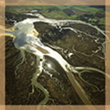
Great locations are drained swamps and drained rivers towards the end of the season when water tables are down, water
pockets form under exposed sand bars and mud flats creating quicksand. Some may only be a few feet deep
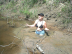
while others can range from knee depth to shoulder depth. Sinking in sand should be taken a little more seriously, sand tends
to drain it's water quite fast leaving you in what would feel like a cement like hold, when this takes place you will
need to relax take a few minutes to look over the situation, in most cases you will have to dig your self out using your hands
or what ever you can find, it may take a while but be calm you will get out.
It helps to have a canoe to get to some of those hard to reach locations since most are far from the road and require
a good hike in, or a long walk along the river bank or shore line. It's best to do all your research at home before you leave
for your trip. Topo maps help a great deal and show all those little rivers and streams that dont show up on regular
maps. The Topo also shows paths and trails that may lead you closer to the water line as well as elevation details
to keep you informed.
|
|
Topographic Maps
Canada and the United states have several great web sites that help with the search, some are free while a few of them
have a monthly fee and others are based on pay per use status. The latest site to be developed is called Keyhole
this site incorperates satalite images from around the glob with excelent features, it is also zoomable right
down to street level. information on the Topo sites has been made available in the LINK's area
|